BUZZ
The latest news about the industry and companies that use 12d Model. Who’s won what, who’s done what, and what’s in the pipeline. If you have some news – or know some news – about a project, let us know here.
Latest Development
Newsletter
Rail transitions | Free 12d access for BOSSI candidates
12d Model upgrade seminars | Electronic lodgement of cadastral data | Roadflow | Drones on construction sites
Estimating rock volumes for Airds Bradbury Renewal
Pacific Highway detail design | Berry Bypass | RMS seeks interest from surveyors | Pacific Highway Upgrade project | Overnight success for Daly Smith | North West Growth Centre
12d Model used in 3D printing
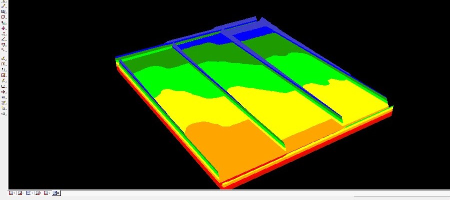
Tahlee Consulting Services (TCS) are specialist Agricultural Surveyors based in Gunnedah, NSW. TCS were commissioned by Precision Cropping Technologies to develop a 3D model of a bankless irrigation field for display at the 2014 Cotton Conference at the Gold Coast.
The model was used to display a new method of flood irrigation and the potential of the field levelling and design capabilities of software available from Precision Cropping Technologies.
12d Model was used to create an exaggerated surface for the field so that small elevation changes (as small as 0.05m) could be easily shown on a 3d print of a 600m x 800m irrigation field scaled to A3 size. See image above.
Survey points were imported into 12d Model with a 30 times factor applied to the ‘z’ axis. Head and tail drains were designed, along with check banks between the three field sections, and a model of 3d faces was created from the surface. This was coloured by heights and saved as a model of faces and exported as a 3D dwg file. Thiess in Brisbane produced the 3d print.
The model was a huge success with only a slight discrepancy between the design and the print, due to the minimum thickness capability of the printer.
Researchers develop global road zoning plan 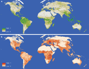
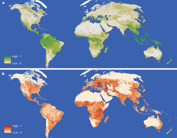
Cross-globe research has resulted in a ‘global zoning plan’ that intends to optimise the locating of road expansion; increasing development benefit while minimising environmental impact.
Experts estimate that by 2050 the planet will see more than 25m km of new roads, a significant part of which will forge into wilderness areas, opening them up to illegal mining, hunting and logging. The Cambridge study aims to balance the conflicting needs of road development and environment protection.
The ‘global plan’ — produced by researchers at Cambridge University in the UK and James Cook University in Australia — is comprised of two layers: one estimating road benefits including increased food production (shown in red), and the other estimating environmental values (shown in green).
In an article in the journal Nature, the researchers say that their approach has revealed areas where road development offers the most benefit, areas where new road projects would be detrimental, and ‘conflict areas’ “where potential costs and benefits are both sizable”.
The key researchers from Cambridge and JCU worked for two years with colleagues and teams from Harvard, Melbourne and Minnesota universities to map out the world’s most important environmental areas, and dovetail them with areas where road development would be of most benefit.
Areas where new roads should be prioritised were estimated to be agricultural regions that are low-yielding but close to urban markets. The researchers say all continents have regions that qualify – including parts of central Eurasia, Central America and Mexico, and the Atlantic region of South America.
Read the full article in Nature on the global road zoning plan.